
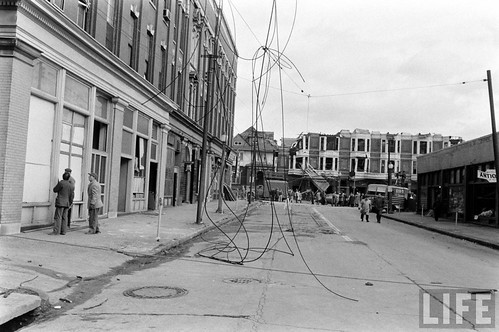
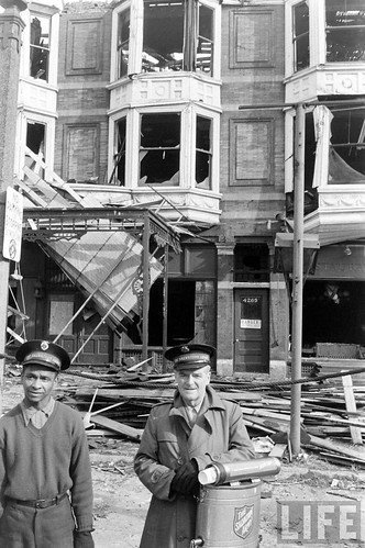
I'm a big fan of old photographs of St. Louis, particularly street scenes. I recently came across a link to search the image archives of Life Magazine through Google, and of course searched St. Louis. Beyond many fashion shots in WU's quad (which are fascinating), baseball, the zoo, Veiled Prophet, etc., a few images of major debris in the streets caught my eye. The images are simply labeled "St. Louis Tornado". The intersection above would otherwise have been almost unrecognizable, but my knowledge of the patterns of devastation brought by major tornadoes through St. Louis history told me that this must be 1959 and somewhere around Gaslight Square.
Everything visible in the first image has been gone since before my memory, so while I knew the general location, placing the intersection did not come immediately. After looking at a few more images, I recognized I recognized a row of buildings that I do remember, and realized the location was Boyle at Olive. What makes the intersection hard to place is not only the clearance of buildings, but the complete re-configuration of the intersection.
Looking east on Olive just west of Boyle. The building on the southwest corner of the intersection was known as the Musical Arts Building long before becoming home to Gaslight Square venues and had been since at least 1909 as its name appears on the Sanborn map below.
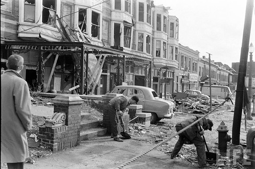
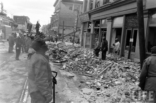
Damage to the Musical Arts building from the tornado was extensive, but not devastating and the building was repaired and put back into use.
 Just three years later on the night of January 10th, 1962, a major fire struck the Musical Arts Building. The photos above and below are from a Post Dispatch photo gallery of the enormous fire caused by a grain explosion at Ralston Purina's mill on Gratiot that occurred the same night. The building just west of the Musical Arts in the photo above was one of the first to go prior to the mass demolitions for Citirama and can be seen in my second Gaslight post in 2007.
Just three years later on the night of January 10th, 1962, a major fire struck the Musical Arts Building. The photos above and below are from a Post Dispatch photo gallery of the enormous fire caused by a grain explosion at Ralston Purina's mill on Gratiot that occurred the same night. The building just west of the Musical Arts in the photo above was one of the first to go prior to the mass demolitions for Citirama and can be seen in my second Gaslight post in 2007. The aftermath of the fire left the building, sidewalks and street all coated in thick layers of ice. Like a cat with nine lives though the Musical Arts Building was re-built again. The building for many years housed the studio of artist Ernest Trova. According to the Post, the it was finally demolished sometime in the 1970's.
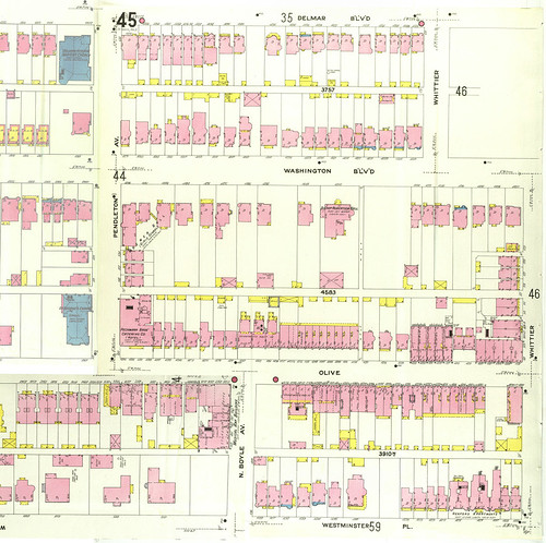
As this 1909 Sanborn Map of Gaslight Square shows, originally Boyle and Pendleton each ended in T intersections at Olive about 260 feet apart. At some point however, possibly due to perceived traffic problems around Gaslight Square, Boyle and Pendleton were joined by the taking of several properties, clearance through demolition and construction of a curved connector. South of Westminster Place, Boyle remains a standard street with 36 feet of pavement (two 10' driving lanes & two 8' lanes). The new connector however was built with a whopping 50 feet of pavement or four 12.5' lanes. For comparison, standard lane width for interstates is 12'.
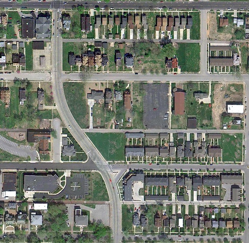
An aerial photo today shows the dramatic change that came with the reconfiguration of the streets. While a four way stop has been put in at Olive, the overbuilt infrastructure still has the feel of a high speed collector road in some far flung suburb. The architecture of the townhouses that have been built in the area, with the exception of a condo building at the southeast corner does not help the feeling of the road.
An aerial photo today shows the dramatic change that came with the reconfiguration of the streets. While a four way stop has been put in at Olive, the overbuilt infrastructure still has the feel of a high speed collector road in some far flung suburb. The architecture of the townhouses that have been built in the area, with the exception of a condo building at the southeast corner does not help the feeling of the road.
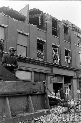
The building at the end of the T in the first photo survived the tornado, but as photos below from the Western Historical Manuscript Collection show, it was re-built as a stripped down ghost of its former self. The bays, while damaged, seemed repairable, but were stripped off along with the decorative brickwork only to be replaced with pairs of windows punched in a blank facade.
 Except fro a coat of white paint, the only thing unaltered was the iron canopy extending over the terrace. This building was demolished along with others for the reconfiguration of Boyle and Pendleton.
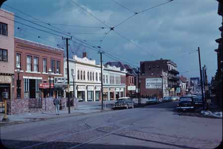 Another view from the intersection looking east. The painted building in the center would survive until 2003. More photos of those can be seen in my first Gaslight Square post.
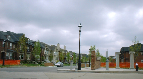
The "new" Gaslight Square looking east from Boyle. Photo by Marjie Kennedy. A fairly attractive 3-story condo building has since filled out the corner behind the columns. The only things recognizable from the old photos are the gas light poles and the Continental Building in the distance. The northeast and southwest corners of the intersection are still empty lots. Hopefully someday something worthy of this storied location will be built there.
6 comments:
How depressing. Gaslight Square, in my opinion is one of the single greatest losses not only to the built environment, but for the entire cultural landscape of St. Louis.
On the subject of lost intersections... ever see old pics of Kingshighway and Delmar? There's a photograph in my "Streets and Streetcars of St. Louis" book and I don't even recognize it. The intersection was filled with density and people-- it looked like Brooklyn. All four corner buildings have been obliterated and each replaced with pathetic anti-urban uses.
I have that book as well, its one of my favorites, and yes, that photo of Delmar & Kingshighway is extremely depressing, especially with Holy Corners just to the south fully intact. Hopefully in the future we can re-build that intersection as well.
Really interesting, and really sad. Thanks for another fascinating bit of STL history.
Here's the photo that depresses me (Vandeventer at Chouteau): http://picasaweb.google.com/lh/photo/kKtVJI9mLuJVPWv6uks3kxS8XME3HtPlZ7B_RkJaJSU?feat=directlink
Nice to see the old photos, they bring back fond memories of when St Louis was a good place to live, and to be entertained.
Now with have the New 64 to admire, an expanded Lambert (largely unused and no longer international) and a MetroLink Extension to nowhere. Next Forest Park to become a large parking lot so the kiddies can see what a train looks like while daddy plays golf? Sprawl and decay continues...
I have a photo of Page Avenue in what is now Pagedale just west of Ferguson Avenue and just east of Pennsylvania Avenue, taken around 1920. Page is a narrow city street with beautiful mansions and businesses lining the north side and the Midland streetcar line (yes, there was such a thing) on a wooded right-of-way on the south side. When the streetcars stopped running Page was widened to four lanes and most everything on both sides was demolished, including beautiful mansions. The photo looks like it was taken in Brooklyn, not St. Louis County. At Ferguson Avenue, another streetcar line, the cross county crossed, north to the Rock Road and South to Vernon Avenue. It is amazon a whole world can disappear.
Post a Comment