Friday, December 24, 2010

Ghosts of Downtown's Christmas Past

Downtown St. Louis Christmas Decorations .jpg
In the late 1950's and early 1960's as new suburban shopping centers lured shoppers away from Downtown St. Louis retail several intersections received these lavish decorations in an effort to turn the district into a winter wonderland during the holiday shopping season.

Christmas Decorations 6th & Washington.jpg
Another view of decorations at 6th & Washington looking south. The Railway Exchange Building, home of Famous Barr (now Macy's) can be seen at the center of the photo. Stix Baer & Fuller was located at the northwest corner of the intersection.

Christmas Candy House 8th & Locust.jpg
This portable Christmas Candy House, was located at the corner of 8th and Locust. Looking south beyond the Chemical Building, the white four story terra cotta building is now the location of the Laclede Gas tower built in 1968. The building seen beyond at the southeast corner of 8th & Pine was demolished in 1977 for an addition to the Wainwright Building. Photos above from the Western Historical Manuscript Collection.

Christmas Castle - Stix Baer & Fuller 7th & Washington 1959.jpg
In 1959 Stix Bear & Fuller constructed this fanciful Christmas castle at the corner of their store at 7th & Washington. Next year the former SBF building will re-open following a top to bottom renovation housing an Embassy Suites Hotel, apartments, ground floor retail and hopefully a Blues Hall of Fame. Photo from the Post-Dispatch.

Tuesday, December 14, 2010

Great News for a Change: May's Clayton Home is Saved

12 Brentmoor 02.jpg
About two years ago I posted the story of the demolition of Morton D. May's Ladue estate, the 1941 International Style masterpiece by Samuel Marx. This holiday season though I have the pleasure of bringing fantastic news!

Yesterday I received the following anonymous comment regarding Morton D. May's second modernist home in Clayton: "Hi Paul! My husband & I recently purchased 12 Brentmoor Park. You will be happy to know that we plan on lovingly restoring it, NOT tearing it down. Thanks for highlighting some local gems!"

Earlier this year, May's Brentmoor home had been listed for sale as a potential tear-down. While the house was in very good shape on the exterior, its semi-gutted interior did not point to a very positive future. Fortunately a couple with the vision to preserve this modern beauty has bucked the trend of destruction for fake castles. To this I can only say THANK YOU!

IMG_7628.JPG

Monday, December 13, 2010

Washington Avenue Part 2: Will We Squander One of Our Oldest Connections to The River

St. Louis 1780 with JNEM overlay.jpg
Beyond being disastrous for Laclede's Landing, the elimination of Washington Avenue from Memorial Drive to the levee would be squandering one of St. Louis' oldest connections to the Mississippi River. The map above shows the extents of the village of St. Louis in 1780. The area shaded in green from Poplar to Washington was taken for the Jefferson National Expansion Memorial (the Gateway Arch and surrounding park).

South of the Arch, Poplar street extends to the river but is blocked by the highway. Plum street has all but disappeared, Cedar and Lombard streets are blocked at First Street by truck lots and the flood wall, leaving Gratiot as the only street still passable from the river to 7th Street, where it becomes a private road through the Nestle Purina corporate campus.

North of the Arch, Lucas is blocked by a parking lot at 2nd Street and Morgan is blocked west of Memorial Drive. Laclede's Landing Boulevard, an access road just south of the MLK Bridge goes through to the river and connects to Convention Plaza, albeit in an extremely awkward and confusing way, but did not exist prior to the late 1970's. All of these blocked and removed streets leaves Washington Avenue as one of St. Louis' only remaining connections to the riverfront from the time of the City's beginnings.

Attack on St. Louis 1780 - Washington Ave.jpg
Another map from 1780 shows that Washington Avenue was one of the few streets that extended outside the fortifications of the village of St. Louis to destinations beyond. The maps from the 1970 printing of "This is Our St. Louis".

Foot of Washington Avenue 1875.jpg
The opening of the Eads Bridge in 1874 solidified Washington Avenue's prominence as one of the most important streets in St. Louis. The photo of the bridge above from Wikimedia was taken at the foot of Washington Avenue at the levee just a year after completion.

Eads Bridge from Missouri Athletic Club.jpg
This photo looking down from the roof of the Missouri Athletic Club (former known as the Missouri Athletic Association) shows the Eads Bridge and the leg of Washington extending to the river.

Washington & 3rd Street.jpg
The building between Washington and the bridge was a the terminus of streetcar lines from East St. Louis that came across the bridge deck. The tracks in the tunnel hidden below and extending across the lower deck of the Eads where MetroLink runs today were used solely for freight trains.

Washington & 3rd 02.jpg

Washington Avenue East Toward Third
Another view of Washington and Third Street (now Washington Avenue) from the Missouri History Museum shows a bustling intersection including a streetcar turnaround. It was a hub of activity connecting the Washington Avenue commercial corridor to Eads Bridge and the river, a glimpse of which can be seen near the right edge of the photo.

IMG_6873.JPG
Today, this intersection is all but obliterated by an elevated highway creating a psychological barrier cutting off St. Louis from the riverfront. Instead of restoring this intersection and its connections by implementing City to River's vision for a new boulevard to replace the highway, the current focus with a deadline of October 2015 includes removing the Washington Avenue connection to the river.

The current 90 day process to refine MVVA's design concept is unfortunately closed to the public, so good luck telling anyone if you agree that Washington Avenue should be kept. A limited number of Downtown stakeholders and organizations do have a chance to have their voices heard as part of this process. Lets just hope that someone listens.

Monday, December 6, 2010

Neptune Fountain is Gone from SLAM's Sculpture Hall

IMG_0194.JPG
Friday evening I finally went to the St. Louis Art Museum to check out the Joe Jones exhibit, which is excellent and I highly recommend everyone see it. As I walked through the glass front doors facing Art Hill into Sculpture Hall though I was somewhat unprepared for what I would encounter. Immediately I saw the plywood wall in front of me and at the same instant sensed the absence of the sound which I have enjoyed in that space all my life. The fountain was gone!

IMG_0196.JPG
I was aware of the plan to remove the fountain, but was still somewhat caught off guard as I had not been inside the museum for several months. I had gone to a few of the public presentations about the museum expansion and knew that others shared my displeasure with the idea of moving the Neptune fountain out of Sculpture Hall. I had hoped that maybe there would be enough public outcry that the museum might change their plans, however that obviously didn't happen.

IMG_0201.JPG
Beyond the plywood wall around the scar in the marble floor where the fountain was located the entire south end of the hall has been walled off and a temporary ceiling is being constructed above. This is presumably so that construction can occur on the new grand staircase to a new lower level hallway leading to galleries and the south building where the restaurant gift shop and auditorium are located.

IMG_0204.JPG
The location of the grand staircase centered in Sculpture Hall (outlined by the tape lines) was likely the reasoning for removing the fountain, because of course you couldn't have a fountain as the focal point at the top of the new grand stair, right?

IMG_2527.JPG
The Neptune fountain as it stood welcoming generations of St. Louisans until recently at the center of the hall. According to a fact sheet about expansion on the museum's website, the fountain will be relocated to a new group entrance at the South Building. Since public parking will be concentrated in the new garage under the addition and on the existing surface parking areas flanking Art Hill, most visitors with the exception of school children and bus tours may never enjoy the fountain.

SLAM Louis LeBeaume Fountain 1928.JPG
The Neptune fountain was not the first in this location. This fountain designed by architect Louis LeBeaume, who with Eugene Klein designed the Kiel Auditorium & Opera House, was installed at the center of Sculpture Hall in 1928. The halls marble floor, also designed by LeBeaume, was installed in the same year. Prior to that time the floor had been bare concrete.

In the photo above, you can see the finish of the walls and ceiling of the hall as they were when the museum was constructed prior to the 1904 Worlds Fair. The walls were buff brick and the panels of the barrel vaulted ceilings were a herringbone patterned brick or tile that resembles a Gaustavino ceiling.

SLAM Sculpture Hall 1950.JPG
By 1950 the original walls and ceilings had been covered over with a cement or plaster parging, still present today.

SLAM Neptune Fountain 1963.JPG
The Neptune fountain by Renaissance sculptor and architect Bartolomeo Ammanati replaced LeBeaume's in 1958 although the the marble base for the former was retained.

SLAM Sculpture Hall 1969.JPG
Sculpture Hall in 1969

SLAM Scupture Hall 1920.jpg
From the time of the fair in 1904 through about 1920 photos show Sculpture Hall packed with a seemingly ridiculous number of works. This type of crowded presentation for both sculptures and paintings was common practice for museums at the time. All historic photos from the St. Louis Art Museum's history page.

Thursday, December 2, 2010

Washington Avenue: Removal East of Memorial Would Devastate Laclede's Landing

Looking Down from Eads Bridge
Washington Avenue from Memorial Dr. to the riverfront. Photo by Melinda Stuart.

As you are probably aware, MVVA's plan for the arch grounds, illustrated below, calls for removal of Washington Avenue east of Memorial Drive to the riverfront and extension of the park to the south face of the Eads Bridge. Although one of the top goals of the City+Arch+River Design Competition was to improve connections, MVVA's plan will effectively create a blockade at the south end of Lacede's Landing. While I am always an advocate for better pedestrian realms, and of course there is the MetroLink at the Eads Bridge, the fact remains that many come and go to Laclede's Landing by car.
MVVA-Plan North.jpg
MVVA'a plan for the "North Gateway" for the most part simply provides redundancy for functions that already exist in the park, including two new gathering spaces. The large central lawn under the Arch as well as the Arch grand staircase are regularly used as gathering spaces for concerts, rallies and other public events. Are two new gathering lawns really needed?
MVVA-North Gateway.jpg
Not only does MVVA's plan block access along the Washington Avenue corridor to the riverfront for autos, but the proposed new "Urban Ecology Center" that would be built largely within the Washington Avenue street right-of-way would block direct access to the river for pedestrians and cyclists as well as create a visual barrier for all. The design narrative states that people would be able to access the riverfront via an elevator within the Urban Ecology Center. This is good to provide a vertical means of accessibility, but bad for all when the building happens to be closed. I wonder how the NPS will feel about people dragging their bikes through the building?
MVVA Urban Ecology Center.png
The placement of the ecology center and providing access and usable spaces at the lowest level, essentially at the top of the levee will have some technical issues as well. According to the photos below that I took in June 2008, they could be inundated by flood waters.
Foot of Wash Ave June 2008.JPG

Wash Ave Flooded june 2008.JPG
High water during the the flood of 2008.

MVVA North Traffic Plan.png
The traffic pattern proposed by MVVA for visitors coming to the north end of the Arch is far from intuitive, and for those coming from the south or west, downright confusing. This same singular path would remain as one of the few remaining ways to access Laclede's Landing by car.
Laclede's Landing-Arch Access.jpg
The proposed Arch access and default Laclede's Landing access would be the north edge of the Landing along the MLK Bridge. Access to a re-built new north Arch parking garage is proposed to be Commercial Street, which is basically a glorified alley. The few original buildings face their backs to the "street".
IMG_0947.JPG
First and 2nd Streets on Laclede's Landing would be blocked at the Eads Bridge creating dead end streets south of Lucas. The demolition of the Switzer Building on First Street, to the left of the yellow barricade in the photo above, has left that block lifeless with no building frontage. Second street retains half of its original buildings but unfortunately faces a parking lot to the west. These vacant lots failed to draw development of new in-fill buildings during one of the best real-estate markets in history that ended a few years ago. Dead ending these blocks would surely doom them to permanent desolation.
IMG_0962.JPG
Some say that these two blocks could just be turned into pedestrian streets. Really!!, pedestrian streets? We tried that along with many other communities across the nation and the majority failed miserably. Lets face it, Laclede's Landing has been struggling for over 25 years largely due to its isolation. The galleries and cute retail stores all closed or moved elsewhere not too many years after opening in the early 1980's. What's left is largely the nightlife scene: bars, a few restaurants, the casino, offices, oh and the creepy wax museum. Removing Washington Avenue and access to Laclede's Landing from the south would be the equivalent of kicking it in the teeth when its already down.
14th Street Pedestrian Mall.jpg
The 14th Street Mall was created with the intent to revitalize the street but ended up as a virtual ghost town as did pedestrian streets almost everywhere. Fortunately 14th street has recently been re-opened to traffic and its buildings newly renovated. Laclede's Landing already has the feeling of a district on life support, hopefully during the 90 day design refinement process of MVVA's concepts now over half complete intelligent decisions will be made not to pull the plug on Washington Avenue and the Landing.

Tuesday, November 16, 2010

The Seven year Saga: Sears South Grand

South Grand Sears 01.jpg

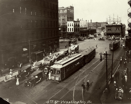
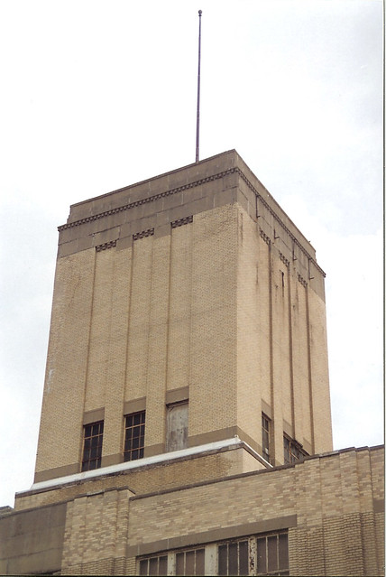
The Art Deco Sears store at 3708 South Grand Boulevard opened in 1929 as the company was expanding its retail store presence across the country. The company that had begun in 1888 as a mail order catalog opened its first retail branch in 1925 in Chicago. By March of 1932, despite the onset of the great depression, Sears had an empire of 381 stores across the U.S. Sears followed a prototype of urban neighborhood stores that were 2 to 3 stories in height and easily identifiable by their trademark tower element. Also opened in 1929, just two blocks north was another Art Deco landmark towering over Grand and Gravois, the 10 story South Side National Bank building.

South Grand Sears 02.jpg
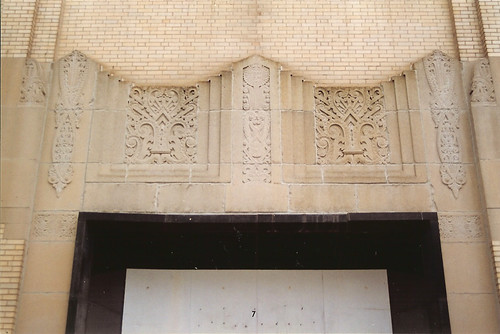
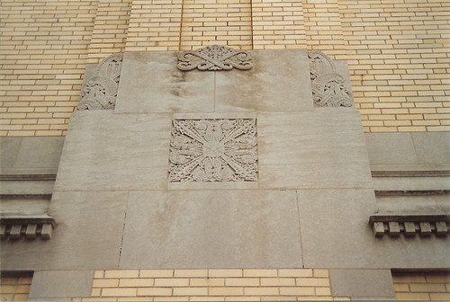
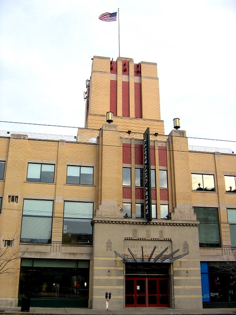
Art Deco stone details over the entrance to the South Grand Sears store.

South Grand Sears 05.jpg

The South Grand Sears had beautiful Art Deco stone detailing. Its sister store built on North Kingshighway between Page and Franklin (now MLK) in 1938, while keeping the same form and proportions as South Grand, exhibits a much more modern look. Gone are the Art Deco details at each column, with the only ornament consisting of fluted limestone flanking the entrances. Horizontal banding of the brick above the entrances and storefront gives sense of streamlined form.

Victor Roberts Bldg. Entrance.png
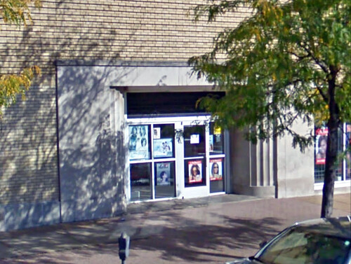
One of two entrances to the former Sears on North Kingshighway.

Sixty years later though, Sears was going through some major adjustments and struggling against competitors. On January 25th 1993 Sears announced the closure of 87 retail stores in 33 states plus the District of Columbia. Included in that closure list was the South Grand Sears store. In the same year Sears also dropped production of its general merchandise catalog due to flagging sales.

South Grand Sears 04.jpg

By 1998, the City of St. Louis had put out an RFP for redevelopment of the site of the abandoned store and parking lot occupying a full block between Arkansas and Tennessee Avenues. Development rights went to Pyramid Construction, an up and coming City homebuilder who proposed 26 new homes and a new commercial building along Grand. This of course included demolition of the Sears store building, which was paid for through City funding.

South Grand Sears 03.jpg
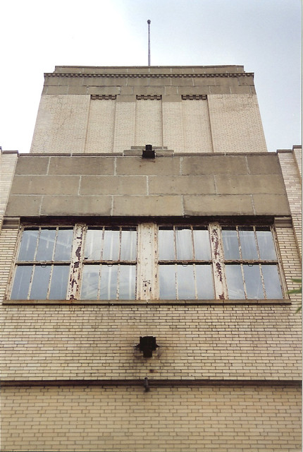
The mis-matched brick over the upper windows indicates that the parapet
was re-built. Given the amount of Art Deco stone detailing below, it is
possible that additional detailing was lost with the repair work.

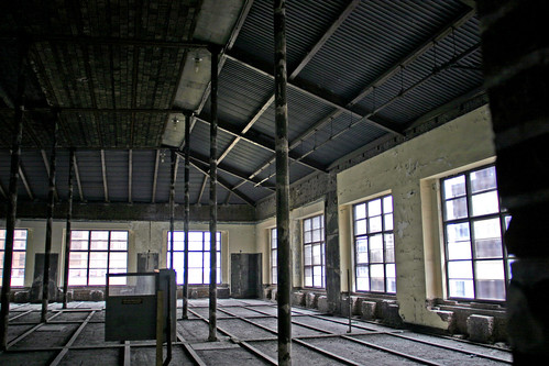
Even though this was the same year that the Missouri Historic Rehabilitation Tax Credit was established, my understanding is that no thought was given to re-using the Sears building as part of the redevelopment by the City or Pyramid. The re-use potential for the building was very high, as it had only been empty for 5 years, had little to no deterioration over that period and was structurally sound. I started work with Pyramid Architects in July 1999, just one month before the demolition permit was applied for by the residential development arm of Pyramid. When I asked why the building was going to to be demolished, the response was that it was part of the deal with the City.

South Grand Sears 06.jpg
Art Deco design extended to the auto service area at the rear of the store.

Unfortunately since the program was brand new, Pyramid had little experience with the Missouri Historic Rehabilitation Tax Credits. What experience it did have was with small scale residential rehabs in the Shaw neighborhood and a few in Forest Park Southeast. Pyramid was just starting a commercial division that year, and its eyes were focused on empty buildings Downtown. The commercial and residential divisions of Pyramid rarely cross pollenated.

Victor Roberts Building.png
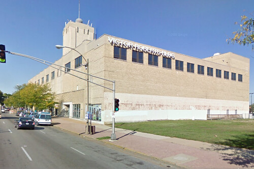
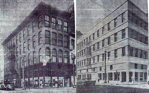
The North Kingshighway Sears saw a much better fate, and was renamed the Victor Roberts Building, the headquarters for the Roberts Companies. While the Roberts Brothers have a mixed history when it comes to historic preservation, their re-use of the Sears building is commendable. The South Grand Sears would have been eligible for listing on the National Register and there is no reason that it should have been demolished. Even without a full blown tax credit gut-rehab, the Roberts Brothers have shown that re-use of the old Sears stores is very possible. At the Roberts building the stainless steel escalators are still used to ferry people from floor to floor.

Lesley University Cambridge Sears Building.jpg
Now part of the campus of Lesley University in Cambridge, Massachusetts, this
is one of many examples of adaptive re-use of former Sears stores across the U.S.

I am not aware that there was much outcry over the demolition of the South Grand Sears store, however it would be an understatement to say that I was out of touch with things happening in this part of the City at that time. If anyone remembers more about this, please comment. By the early months of 2000 demolition of the old Sears store was complete. This however was just the beginning of the story of this property.

Sears South Grand Site.jpg
The empty Sears site on Grand with new homes rising beyond.

Later the same year South Side National Bank announced that they intended to sell their building to Walgreens, who intended to demolish the landmark tower for a suburban prototype store. Fortunately in this case, neighborhood activism stopped this demolition, led in large by Jennifer Florida, who would be elected alderman of the 15th Ward in 2001.

Keystone Plaza rendering.jpg
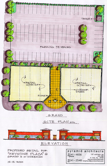
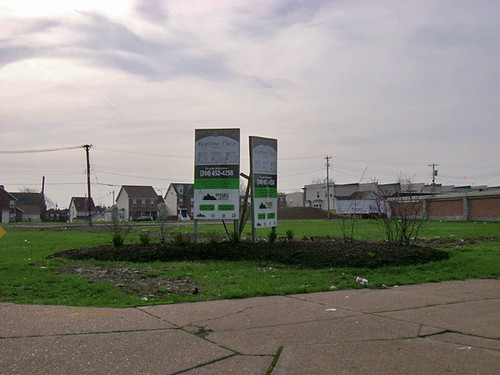
A failed plan for retail development on the former Sears site.

Back at Grand and Winnebago Pyramid was having problems developing the commercial portion of the Sears site. After several years of marketing the site, the former Sears location still sat a vacant. In February 2005 however, a plan emerged that involved Pyramid swapping the Sears site for the existing McDonald's across the street. McDonald's would build a new suburban prototype store on the Sears site, and Pyramid would build a new apartment building for seniors on the McDonald's site.

From the beginning, this plan seemed rife with logic errors. While we had nothing to do with the new McDonald's, Pyramid Architects did work on the senior apartment building. While we made it work, the sloping site where the old McDonald's was located was far from ideal, and the project also hinged on acquiring a non-historic storage building on an adjacent lot. The owner of this building was apparently not very cooperative. Fortunately, the St. Louis urbanist community was not cooperative about the new suburban style McDonald's either.

Alderman Florida who had won wide support of her stance against demolition of the South Side National Bank found that support turn to vehement opposition when she supported Pyramid's McDonald's plan. Opponents held protests, attended meeting, hearings and even attempted to unseat Alderman Florida through a recall election. The topic was covered extensively on Urban Review STL.

Florida T-Shirt
Some who were infuriated by Alderman Jennifer Florida's
support of the McDonald's plan had these shirts printed.

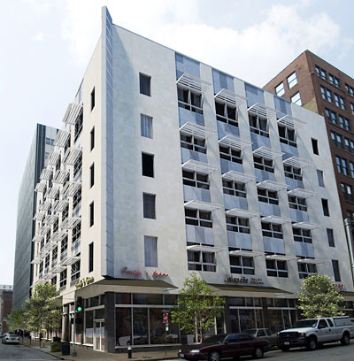
Ultimately in late 2006, those who protested the McDonald's plan won out when Pyramid announced that the land swap was dead and it intended to build the senior apartment building on the former Sears site, thus ending a seven year saga of the fate of a site that should not have been cleared in the first place. The new building got underway in late 2007 and was completed after Pyramid's demise in 2008.

Grand South Senior Apartments 01.jpg
The Grand South Senior Apartments were completed in late 2008. while it is not a bad building, its relatively bland appearance is a far cry from the beauty of the former Sears store. One thing that was done right with this building was the introduction of retails spaces on the ground floor facing Grand.

Grand South Senior Apartments 02.jpg

Friday, October 22, 2010

Hiding in Plain Sight Part 3: Living in Second Life

411 Rendering - Farm & Home Building.jpg
Another example of an early 20th century building Downtown that received a new modern slip cover is the Farm & Home Savings Association at 10th and Locust. The current modern skin was applied to the building in 1954. Farm & Home had purchased the building for its new St. Louis headquarters.

Kinloch Building.jpg
The six story building was originally constructed in the Romanesque style in 1905 as the central exchange for the Kinloch Telephone Company. In 1900 Kinloch had surpassed the rival Bell Telephone Company in number of subscribers, making it St. Louis' largest telephone company at the time. Kinloch sold out to Bell in 1924.

Farm & Home 02.jpg
Back to the question of whether a "modernized" building can be restored to its former appearance. The answer as seen in my previous post is: sometimes yes, but in this case, the answer is sometimes no. Both the former Post-Dispatch Building and the 1015 Locust Building are both examples of modernizations that were accomplished by hanging an aluminum and glass curtain wall on the building. As the name implies, the new window and metal panel systems were hung on brackets attached to the masonry structure and like a curtain, there was a small amount of space between the new wall system and the building. In the case of the Post-Dispatch, this allowed the curtain wall to slip over many decorative elements that protruded from the face of the building. This allowed for removal and restoration of the areas that were damaged.

In the case of the Farm & Home Building, a new stone veneer and metal panel system was applied directly to the face of the the original building. This meant that all decorative elements including arches, sills, band courses, cornice, etc. that protruded beyond the face of the field masonry were literally shaved clean off of the building. When Craig Heller bought the building several years ago, he had several of the stone panels removed to investigate the possibility of restoration. As you can see from the photo above, the damage to the brick and terra cotta decoration was extensive. Restoration would have meant a very expensive complete re-construction of all the decorative elements from scratch. Even if the money were available to do this, when damage is this extensive you have to ask yourself "is it worth it?"
Farm & Home 1954 Rendering.jpg
Before the complete modernization of the building, apparently Farm & Home considered a more modest remodeling of the facade. As seen in the rendering above, this would have left
much of the original detail of the building intact. Because the Farm & Home modernization had been completed in the mid-1950's, the new skin was able to be considered to have achieved enough significance in the building's history that it was listed on the National Register with the modern facade. The original Kinloch Building photo, rendering above and three side by sides below are all from the building's nomination.

6th & Olive slip cover.jpg
After World War 2, there was a wave of building modernizations in Downtown St. Louis as owners wanted to both "update" the look of their properties and compete with new construction. The building above was at 6th & Olive.

Dunn's 526 Pine Street.jpg
Another modernization above at 526 Pine Street and below at 1100 Olive.

Conroy Building 1100 Olive.jpg
All three of these "before and after" examples have since been demolished.

Merc Library sm.JPG
Further east at Broadway and Locust is another example of a prominent building that was modernized in the mid-1950's was the Mercantile Library Building. St. Louis' oldest cultural institution, the Mercantile Library was founded in 1846 and is the oldest continually operating library west of the Mississippi. In 1854 the Mercantile Library built its first building at Broadway and Locust then in 1887 began construction of a larger six story building on the same site which was dedicated in 1889.

Mercantile Library Building 2010.jpg
In 1955 the building received a modernization very similar to that of the Farm & Home Building. A granite base was applied to the first floor, limestone veneer wrapped its midsection, and finally red brick was applied to the 6th floor and a severely truncated parapet compared to that originally built. The modernization also included a large new addition to the west of the original building as well as the incorporation of a neighboring building to the south an another facing 6th Street to the west.

First Nat Bank Merc Lib Bldg-1923.jpg
An old advertisement fro marble ant tile shows the opulent interior of the First National Bank of St. Louis which was a main first floor tenant. An image from the Missouri History Museum shows the buildings exterior covered in patriotic bunting on the bank's opening day, July 7, 1919. Prior to construction of the Century Building, Scruggs Vandervoort Barney had also been an early tenant.
First National Bank Interior.jpg
This is all that is left of that interior today, although much of the original interior was probably gutted and covered over during the buildings expansion and modernization in 1955.

IMG_3937a.jpg
A photo shows how the large arched windows on the second and fifth floors were partially filled-in during the modernization. Unfortunately the method of attachment of the stone panels here at the Mercantile Library was the same as that of the Farm & Home. All of the decorative features were shaved off to give a clean flat surface for hanging the new stone. Pyramid determined that even if we had wanted to restore the exterior that because the building had lost so much of its original fabric both on the exterior and interior, including almost complete removal of the south and west walls during expansion, that the original 1889 building would not be eligible for listing on the National Register.

Mercantile Library Interior.jpg
A century after it erected its fortress of knowledge, the Mercantile Library found itself an aging institution with dwindling resources. The library was private and relied on memberships and contributions to sustain itself. With a glut of new office space in Downtown St. Louis after the 1980's building boom, the library also found itself almost the only occupant of its now 250,000 square foot building. Instead of closing its doors, in 1998 the Library made the decision to move to the University of Missouri St. Louis campus. Gone is the once opulent sixth floor reading room and the mezzanine library stacks. Like the Farm & Home, the Mercantile Library is eligible for listing on the National Register as a modern building. With this and a now a blank canvas inside, the building is ready to live its next life when the economy is ready.