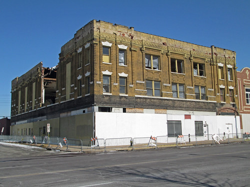
 A demolition permit application was applied for on January 31st for the Castle Ballroom at the corner of Olive Street and T. E. Huntley (formerly known as Ewing). The buildings roof suffered a partial collapse in November of last year when one of the large timber trusses that spanned the ballroom space failed.
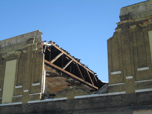 The truss failure caused two bays of the roof to collapse and as it fell, the truss pushed out a portion of the west wall causing it to fall outward. The Building Division issued an emergency condemnation on November 18th, 2013.
While the damage may look devastating, a partial collapse such as this should not automatically mean the end of this building. The damage is quite repairable, affecting a small percentage of the facade and of the overall building structure. Many buildings have been rehabilitated with similar or even worse conditions including the M-Lofts, the Lister Building, the Polar Wave building and many more. The cost of demolition, estimated at $50,000 would likely be comparable to the cost of re-building the collapsed portion, and when completed, the owner still retains a valuable asset instead of a vacant lot. If incorporated into an overall rehabilitation project, the re-building costs would also be tax credit eligible.
 The building was placed on the National Register on in March 2011 by the owners, SAG Properties, to make the building more attractive for rehabilitation with the use of Historic Tax Credits. Photos above and below are from the nomination. Although the building is listed on the National Register, the Cultural Resources Office confirmed that they will have no jurisdiction over the proposed demolition because of the emergency condemnation.
 An interior view of the ballroom from the rear balcony shows that the interior features of the space were largely intact before the collapse.
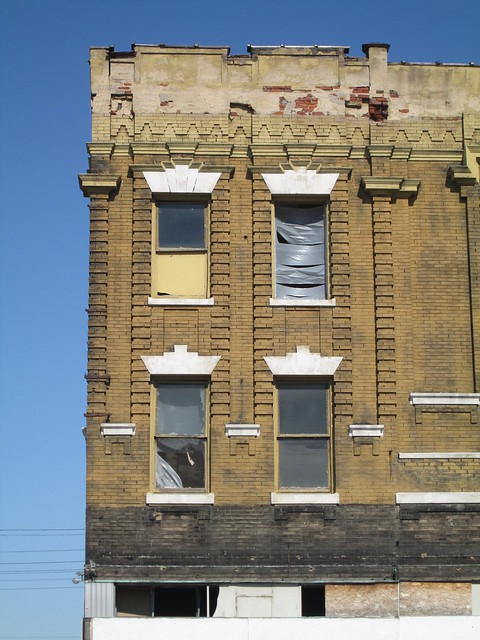 The building was constructed in 1908 as "Cave Hall" in a Renaissance revival style with rusticated pilasters of brick with bold detailing above the window heads and near the top of the pilasters executed in sheet metal. The brick was long ago painted an ocher yellow color, but was originally tan colored. The removal of a bad mansard that had been installed over the storefronts reveals the original color, which was heavily soiled from pollution.
 The decorative brick and sheet metal work give the street elevations a great amount of depth on what would otherwise be fairly flat facades. The loss of this building on a stretch of Olive that has been so depleted will be awful, especially considering how many buildings in the Midtown Alley area have been renovated in the last several years.
I found out about the demolition application in a roundabout way. A little over a week ago I saw a post on Facebook mentioning that a demolition permit had been applied for on yet another building in Grand Center at 3829 Olive. The application had been listed on Lewis Reed's Demolition Docket page as applied for by SAG Properties on January 31st. 3829 Olive is a vacant lot that the City's property database shows is owned by Grand Center, Inc.

I figured maybe the application was for this building immediately east at 3821 Olive, also owned by Grand Center, Inc. While it wouldn't be the first needless demolition in Grand Center, but it still didn't make sense. On a hunch that the address had been wrong, I checked the Castle Ballroom on the City's property database and sure enough found the demolition permit application dated January 31st. The address for the Castle Ballroom is 2839 Olive. It seems that another clerical error at the Building Division resulted in the address numbers being transposed.
The Docket page has been updated with the correct address. They get their information directly from the Building Division, only correcting blatantly obvious mistakes such as street name mis-spellings, which are apparently fairly common.
The circa 1863 Gothic style cottage that was home to the Book House for almost 30 years has been demolished. Michelle Barron, owner of the Book House bookstore (but not the house) sent me these photos today. I posted last April that The Book House was being forced to move because the historic house and several other small buildings on adjacent parcels were to be demolished for construction of a new self storage facility. The recent photo above shows the cottage stripped of its windows and doors just prior to demolition.
Michelle captured these shots of the last corner of the cottage being flattened.
Yet another example of Rock Hill U-Gas Hill rolling over for any new development and letting the history of their community be destroyed.
A shot looking in a window of the cottage prior to demolition.
A photo of the Book House when it still housed the book store. There is a silver lining to this story: the Book House bookstore has found a new home in historic downtown Maplewood! The new store location is 7352 Manchester, just east of Sutton. They have spent the last few months renovating the space and are targeting February 10th to re-open the store. This is good news indeed as a dwindling number of independent bookstores fight to sustain themselves.
Demolition crews have made progress with the demolitions of Jewish Hospital and the adjacent School of Nursing along Kingshighway in preparation for a large two-tower complex that will replace the older buildings on the north end of BJC's central campus.
Demolition of the Moses Shoenberg Memorial School of Nursing is almost complete, temporarily exposing the full side elevation of the massive Children's Hospital building.
Windows are being removed from Jewish Hospital in preparation for demolition
Looking down Parkview Place along the south elevation of the 1926 hospital. The ultra modern Steinberg Building addition opened in 1967 will also be demolished.
A closeup of the southwest corner of Jewish Hospital. Since the announcement last year of the demolitions and replacement complex, other than some simple massing diagrams, little detail has been revealed about what the new structures will look like. BJC has set up live webcams so you can follow the progress of demolition and construction to follow.
One of my favorite things about a major snow storm is that it reduces us to for the most part to the most basic form of transport, walking. Those who remember the last "snowmageddon" in St. Louis will recall that it paralyzed the City for over a week. As a pre-teen at the time I was quite excited that school was canceled for at least as long.
STL Style posted this photo yesterday from the cover of the Post-Dispatch Special Report about the winter storm of 1982. The view is down the middle of Olive Street looking east from Jefferson. While much remains the same today, some major buildings in the middle ground of the photo have since disappeared.
At the northeast corner of 19th & Olive stood this streamline modern building built in 1940 for the A. S. Aloe Company, purveyors of surgical and laboratory supplies. Sherwood Medical occupied the building until 1990 when it moved to a newly constructed building occupying the block west between 19th & 20th Streets. While the new building was built with a parking garage on the first few floors, in the fall of 1996 Sherwood demolished the Aloe building for a surface parking lot. Sherwood vacated the new building and moved from St. Louis entirely two years later on orders from its parent company, Tyco. For more photos including its demolition, see Built St. Louis' page on the building. Photo above and photos below are from a 1985 architectural survey that covered Downtown West from Tucker to 20th Street.
Also demolished with the A.S. Aloe Building was this attached building at 1813 Olive.
Directly across Olive from the Aloe building stood this large seven story building spanning from Olive to Pine Street along 19th that was home to Century Electric Company. The difference in brick and color indicates that it was built in two phases.
The larger south portion of the building, which had its decorative cornice removed, was likely built first, followed by the portion along Olive. The addition replaced a 5 story mill construction building occupying the same footprint according to the 1909 Sanborn map. Century electric would later construct a prominent International Style building a block south on Chestnut Street in 1942, which was horribly re-faced in the 1980's.
Just east of the Century Electric building was this five story building constructed for the Sylvester C. Judge Hat Company. Both buildings were demolished not long after the architectural survey was completed and replaced with a five story office building addressed at 1881 Pine Street that was completed in 1987 (photo below). Looking at the design of the building it is easy to wonder if there was some influence from the Aloe Building that was still standing at the time. The building was recently sold and re-purposed for a French language immersion charter school.
Finally, the snow photo at the beginning of this post also captures the former St. Louis Post Dispatch Building during its period of confinement behind a 1960's modern skin. The building was unmasked and beautifully restored in 1999.
The three story and adjacent one story warehouses lost to a four-alarm fire on December 16th may have been one of the oldest surviving buildings on Chouteau's Landing. City property records list the structure as being built in 1902, however the intricate brick work of it's 1st street elevation suggested that it may have been older. Photo above by Ann Aurbach
Consulting the 1876 Whipple fire insurance maps, that are available online from Washington University and the Missouri History Museum, I found both the three story building, listed as "Central Warehouse A", and the adjacent one story warehouse to the south, listed as "Central Warehouse B". Just north, the surviving three story warehouse hat has the large corrugated sheet metal structure perched on its roof also appears to be on the 1876 map. The buildings are in the upper right portion of the map above.
Other than a few small buildings surviving on 4th Street, the only other structure extant from the 1876 map is the St. Mary of Victories Church and adjacent school. The church is by far the oldest structure in the area, having been constructed in 1843.
The warehouses along 1st Street, or Main Street as it was called at that time, must have been constructed right around 1875-1876 because they do not show up in Compton & Dry's aerial view of the area from Pictoral St. Louis, which was published in 1875.
By the time this 1909 Sanborn map was published the giant Crumden Martin complex by architects Mauran, Russell & Garden was taking shape a block south between Cedar and Gratiot. The buildings shown above had been built between 1904 and 1907. The building that partially burned just over 2 years ago, and still stands roofless would be built three years later in 1912. The Powell Square Building, which was built for Milliken Pharmaceutical in 1916 a block west at 217 Cedar, was wastefully demolished by the City of St. Louis early this year. The Crumden Martin block would be finished out at Cedar & 2nd in 1920 with the construction of a crenelated concrete structure designed by Tom P. Barnett.
Central Warehouse A and a smaller portion of Central Warehouse B would later survive partial demolition for a railroad trestle that connected existing alignments allowing trains to turn south from the central rail yards south of Downtown to the trestle running along the riverfront. I am unsure of the date of construction of the trestle, but it shows up in an aerial view from 1958.
This view from 1st Street at Cedar shows the small portion of Central Warehouse B that remained after the trestle construction.
As was common in the first half of the 20th Century, the testle construction took only what was needed from the larger Warehouse A building, and constructing a new board formed concrete wall to close up the building just a few feet from the trestle. Ann Aurbach has posted about a dozen photos of the grizzly aftermath of the recent fire that finally destroyed both Warehouse A and B on her blog Biscuits with Honey.
What ultimately happens to this site and to the larger Chouteau's Landing district remains to be seen. The district's remaining historic buildings and growing stock of vacant land hold great potential with a location immediately adjacent to Downtown St. Louis, the Arch grounds and the riverfront, which will soon be vastly improved with a new bike and walking trail currently under construction by Great Rivers Greenway including a trailhead at the foot of Chouteau Avenue. Despite these assets the district remains gravely isolated by the urban planning mistakes of the last century and portions of MVVA's plans to revamp the Arch Grounds and connect to Chouteau's Landing have apparently been eliminated due to budgetary constraints. Needless to say, it will take some major infrastructure changes/improvements and developers willing to risk investing in uncharted territory to tap the potential of Chouteau's Landing.
Last weekend I was driving out Olive Boulevard past Hanley Road and noticed that this unique building has disappeared. The interesting feature that made this building stand out was the sculpture like wall of projecting and recessed rectangular brick panels. The buildings entrance canopy was also attractive but ingeniously simple, composed of some steel tubes and a standard pair of standard double T precast concrete sections.
Another view shows that what would ordinarily have bee a plain and boring windowless facade was transformed into an attractive work of art with some simple pushing and pulling of the brick face. The effect was subtle, yet more powerful due to the random pattern used.
The building was somewhat oddly configured with two relatively narrow wings. The rear wing had multiple garage doors opening to the asphalt lot. Whatever business occurred back there was masterfully screened from view to the street. I do not know who the architect was, so if any reader happens to know, please share. The building was for sale last year, but apparently the new owner did not purchase for the building and there was no sign on the lot indicating what is to come as of last week. If they had been looking for a vacant site, they would have needed to go no further than two lots west to the still vacant site where the Arcade Lanes bowling alley burned in 2003.
 UPDATE: Yesterday A City official contacted me about this demolition. The City did not demolish the building due to the earlier condemnation as I assumed, but instead, the application came from the owner. The demolition was approved without review because apparently in the transfer of information from City Hall, where the application originated to 1520 Market Street where the Cultural Resources Office is located, the address of the building was incorrectly entered. The address entered put the building outside of the S. 4th Street National Register district where the building is actually located, so CRO did not review the application. Also, it is rumored that a new owner has closed on the purchase of the property from Steve Murphy.
On Wednesday this photo of the demolition of 818-822 S. 4th Street was posted on Twitter by Alternative Apparel, which is part of the Collective at the MX. The building was located at 4th & Lombard, just north of the old approach ramp for the MacArthur Bridge, on the western edge of the now moribund Chouteau's Landing District. The building is owned by Steve Murphy who headed the now defunct Chivvis Development, which rehabilitated several buildings along 4th Street. You may recall that Murphy also owned the prominent Powell Square Building which the City of St. Louis demolished at the beginning of this year.
 Built in 1890 for a saloon and butcher shop, the building has been been empty for many years. It was most recently known for the colorful paintings by local artist Peat Wollaeger. No news if Beardy McGreen will be saved. The structure was a contributing building in the South Fourth Street Commercial District, a National Register historic district that was created in 2006.
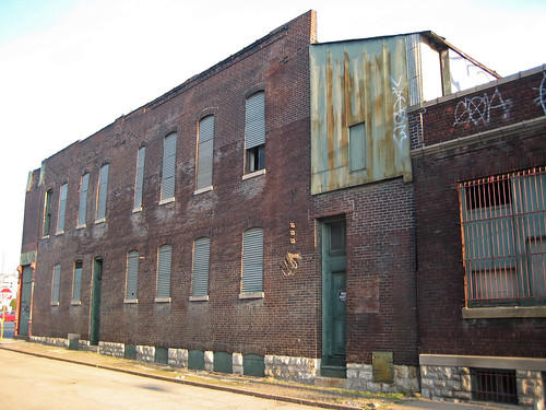 A view of the building from Lombard. Earlier this year the City of St. Louis issued an emergency structural condemnation for reasons unknown.
 The structure at the rear of the property is a separate building that was built in 1917 as an office and warehouse for Saxony Mills, a large flour mill located across Lombard since 1849. The mill was demolished for the construction of Interstate 55. The 1909 Sanborn map for the area shows this building as a 3 story structure. It is unknown when the upper floors were removed. Also unknown is whether this structure is being demolished with the front building. They were built on separate parcels and later combined into one property. I fear for this building because with "emergency" demolitions the City is typically not smart enough to discern that there is more than one building on a parcel, so everything gets wrecked.
 The interior of 818-822 S. 4th had been gutted down to studs. As of a few years ago, the interior of the structure was in decent shape although there were soft areas in the floors and a few isolated areas where the joists were quite deteriorated. The masonry shell was in good condition and the overall structure sound.
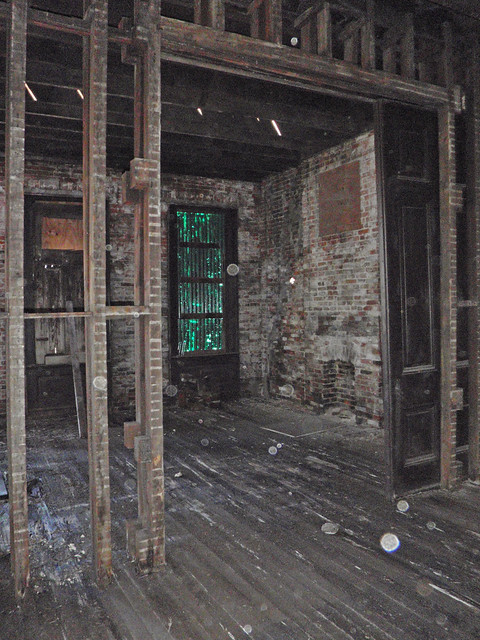 Another interior view of the second floor of 818-822 S. 4th.
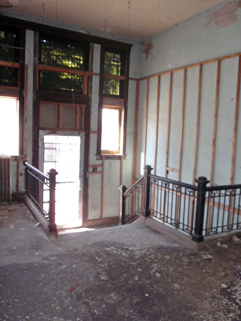 Interior view of the entrance to the building at 321 Lombard.
 This building had apparently been used more recently than the building on 4th Street and was in excellent condition.
 An interior view of the loading dock area of 321 Lombard at the north end of the building. The building is a concrete frame structure with brick infill walls.
 The buildings at 818-822 S. 4th, 317 Lombard and a small one story addition at 812-816 S. 4th are at the center of the historic district. Their loss (if indeed the entirety is being demolished) would be very damaging to the continuity of the district, which with the large gap in the middle was already fragile. As of the beginning of last week, the Cultural Resources Office had not received anything an application for this demolition,
 which is likely a result of the "emergency" condemnation.
If this building had begun to collapse into one of the streets, which no one has made indications of, an "emergency" action might be justified, but if this was simply another building that lost part of its roof or a section of floor to inward collapse, then we are losing another building (or maybe two) for no good reason at all.


