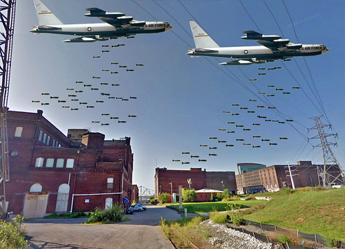
This is the first thing I thought of when I saw the site plan for the proposed new NFL stadium on the North Riverfront announced in early January by David Peacock and Robert Blitz of the St. Louis NFL Task Force. I immediately started thinking of an alternative plan for a new stadium that doesn't require such wanton destruction.
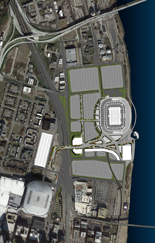
As currently proposed, the stadium and its surrounding sea of surface parking lots, walkways and parking structures would completely wipe out the North Riverfront Industrial Historic District with exception of the Ashley Street Power Plant, which is still used by Trigen to feed the Downtown St. Louis steam loop. Also to be demolished would be the south half of the North Broadway Wholesale & Warehouse Historic District including Shady Jack's Saloon as well as Farmworks, a transitional housing development by Craig Heller and the Cotton Belt Freight Depot, both individual National Register historic properties.
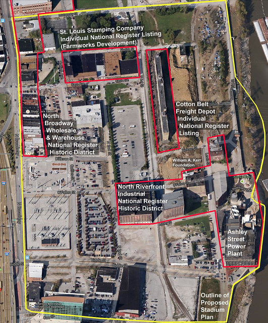
An aerial view of the historic districts and individual National Register historic buildings (outlined in red) that would be demolished by the current stadium proposal (outlined in yellow). Below is a graphic provided by the NFL Task Force that overlays the stadium over the existing context of the North Riverfront. I have highlighted the buildings that would be demolished.
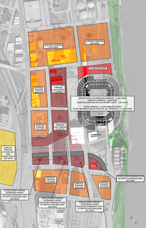
The alternative plan would build the same open air stadium as proposed by the NFL Task Force, but would simply move it just south of the Ashley Street Power Plant and across 2nd Street from Lumiere Casino and the Four Seasons Hotel. Loading and services would access the stadium via Leonor K Sullivan from the south and Lewis Street from the north under a pedestrian promenade that would extend all the way around the stadium and out over the river. The existing railroad tracks would also be re-routed on a new trestle around the east side of the stadium (the current plan re-routes the tracks west of the stadium).
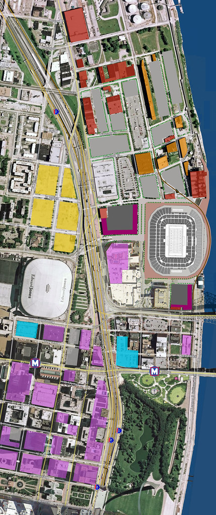
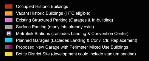
This stadium plan would not only significantly reduce the $90-$110 million estimated budget for demolition, environmental remediation and land purchase, but by moving it 1,600 feet south, would also better integrate the stadium with Downtown St. Louis and Lacledes Landing, positioning it to better take advantage of MetroLink and the plethora of existing parking infrastructure that is already present near the Edward Jones Dome.
The south end of the alternate stadium location would be only about 1,125 feet from the Lacledes Landing MetroLink station, well within the 1/4 mile considered to be a comfortable walk. The current planned location would be 2,725 feet or over over a half mile from the station, which could deter some from taking the train.
The same goes for existing parking infrastructure. Why waste millions of dollars duplicating existing parking spaces when a closer stadium location would put existing garages near the Edward Jones Dome and some garages in the Central Business District, including the large garage at Broadway & Locust and the MX Garage (former St. Louis Centre) nearly as close or closer than the Kiener East & West Garages are to the Dome?
Locating the stadium nearly 1/3 mile farther north would leave garages in the CBD sitting largely empty, not to mention the area restaurants that currently fill with fans before and after football games, and other events at the Dome.
Similar to the present proposal, the alternate plan would include some new structured parking with mixed use buildings built around the perimeter. Locating these farther south as well would allow them to be better utilized on a regular basis, serving Lacledes Landing, Lumiere Place and events at the convention center.
Locating the stadium just east of Lumiere Place could also help jump-start redevelopment of several historic buildings in the North Riverfront Industrial Historic District as well as the Cotton Belt building. Using Historic Tax Credits, these buildings could become residential and office lofts with ground floor spaces for restaurants, bars and other commercial uses... instead of becoming landfill.
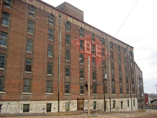
Shapleigh Hardware Warehouse #3 built in 1903 & 1906 fills the entire block between 1st, 2nd, Ashley and O'Fallon Streets. This view showing window detailing similar to some of the Cupples warehouses is along Ashley looking toward the river. Just beyond is a smaller 6 story warehouse built in 1903 for the Beck & Corbitt Iron Company.

Looking east on O'Fallon Street, the small building on the left was built in 1894 for the Belcher Water Bath Company in 1894 and is now the home of the William A. Kerr Foundation.
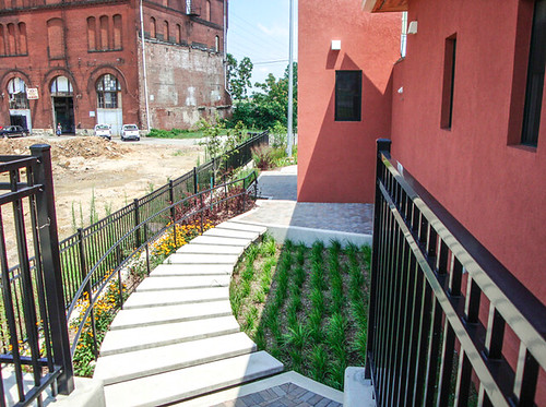
Rehabilitation of the building in 2004 for the foundation achieved LEED Platinum Certification and includes a plethora of green building features including a green roof. It wouldn't be very sustainable to bulldoze it into the ground now, would it? Photo from the Kerr Foundation website.
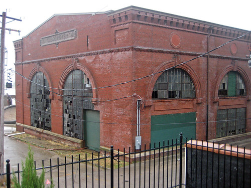
The Laclede Power Company Building was built in 1901 at Lewis and O'Fallon Streets just north of the Ashley Street Power Plant and was later used by Union Electric for electricity generation. More recently, in the mid 2000's, Trailnet proposed renovating the building as a multi-use facility that would include a trailhead for the North Riverfront Trail, a restaurant, bike shop, event and office space. Unfortunately the project was not completed.
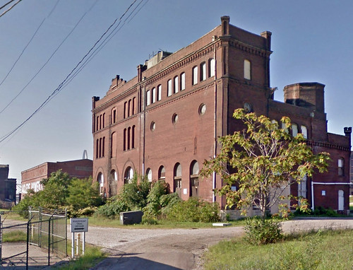
This castle-like building was built in 1900 for the St. Louis Cold Storage Company at 1312-22 Lewis Street. It is one of several buildings in the district that has been proposed for residential rehabilitation in the last dozen years, but still waits.
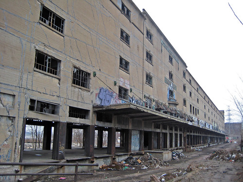
Measuring 750 in length, the massive Cotton Belt Freight Depot Building was built adjacent to the Cotton Belt Line railroad in 1913 entirely of site-formed concrete. Although still vacant, the building has been used for the last dozen years for the annual Artica arts festival.
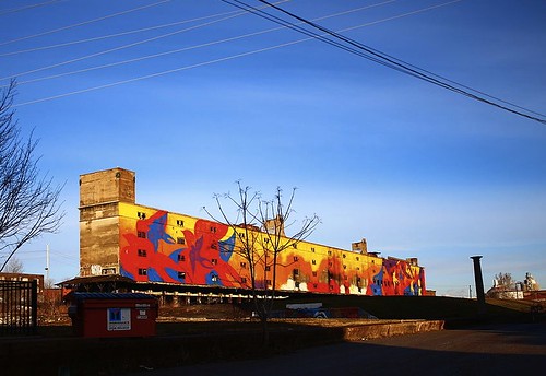
The east side of the Cotten Belt Building was recently transformed into a giant mural called Migrate, which is highly visible to drivers crossing the new Stan Musial Veterans Memorial Bridge.

Developed by Craig Heller's Loftworks, FarmWorks is a multi-use facility that streches across five buildings along Cass Avenue between 1st Street and Collins Avenue. It includes the St. Louis Stamping Lofts, which provides transitional housing with supportive services and job training, and urban farm with indoor and outdoor growing facilities, a green business incubator focusing on locally grown foods, an educational facility, an anaerobic digester that turns food waste into methane, and a CNG fueling station.
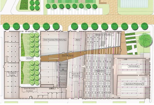
A floor plan rendering of FarmWorks from their website.
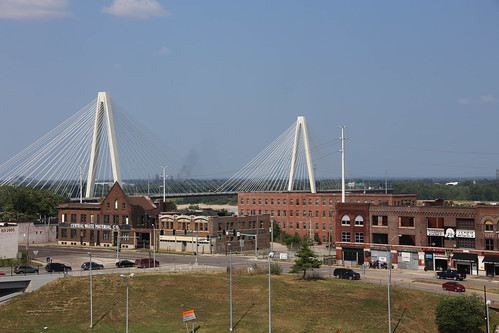
Along north Broadway is a series of buildings that are mostly occupied buildings that comprise the southern half of the North Broadway Wholesale & Warehouse Historic District. Probably the most well known business in this row is Shady Jack's Saloon, which has to be the worlds friendliest biker bar. If you have never been, you should go have their Simple Breakfast, which comes with 2 eggs, bacon, sausage, hash browns, toast and on weekends a complimentary bloody mary, all for $6.95! We cannot lose this for another parking lot! Photo by Paul Sableman

16 comments:
Great post, Paul. A question and a comment....
Question: Do we know how the FarmWorks portion of the Stamping Lofts project is going? I think it may have been a slow go with perhaps the low cost of oil/gas giving a setback to the methane production which I believe was first up... they pored the site for the anaerobic disgestor last winter but I don't think its been completed
Comment: My hope is that the Peacock people see that the infrastructure costs are just too high and the east riverfront becomes the stadium site. I think the vast parking is a feature and not a bug as it will be a key source of revenue for the team and/or stadium authority; that is why there has been no attempt to incorporate historic preservation into the mix.
Not sure how the FarmWorks side is doing, but it would make sense that selling methane would be affected by ups & downs of fuel prices.
If a new stadium is to be built, I'm sure the City of St. Louis will fight hard to have it remain within their boundaries for the tax revenue.
New stadiums across the country are often being incorporated into large multi-use developments (not surrounded only by seas of parking), and there is no reason that cannot happen here. This is exactly what Kronke is proposing in Inglewood.
It would seem like for any proposal along the riverfront downtown that the train line is going to be the biggest obstacle. Moving it around, sliding it one way or another just seems to be unwieldy in terms of siting. Not only the costs associated with moving them, but all the intricacies needed with max train turns, etc. If that spur could go away, removing it from the arch grounds, removing its elevated tracks from Laclede, etc. and removing it from the stadium equation makes sense to me (although it likely doesn't make sense to the industry further north from these areas). It acts as a barrier as much as the highway does just a few blocks to its east. To me, this (and flood concerns) explains why it's all parking along LKS north of the Arch grounds when it could be retail and hospitality directly along the river.
Regardless of the train component, I think bringing the stadium further south and tying it partially to some urban density is the right thing. Laclede could use the boost, and I'm sure Lumiere could reach some agreement on its parking lot. Your comment about the stadium HAVING to be surrounded by parking being a fallacy is spot on. Kroenke is a developer of retail and property, not a parking lot owner.
While this better integrates a new, open-air stadium into the existing urban fabric, it ignores the general voter sentiment that no more local tax dollars should be going to support an NFL team . . .
In regards to Rich's comment about the rail line, I don't believe eliminating the rail line is a viable option. It isn't simply a spur to serve North side industries. If that were the case, then yes, the industries could probably be alternatively served by other rail lines from the north. But in fact, this line links thru traffic from the Union Pacific and BNSF railways from the west and south that converge roughly at Union Station with the Merchant's Bridge to Illinois. And there isn't another south side to north side rail link in the city.
Interestingly (to me at least) there used to be another way north from downtown by rail, albeit a circuitous one used by the Wabash Railroad. Eastbound Wabash passenger trains (to Detroit and Chicago) would leave Union Station proceeding WESTbound and head northwest on what is now the Metrolink right-of-way, make a stop at Delmar Station, and at appx Page Ave, head onto a TRRA line called the Central Belt taking them back east to the Merchant's Bridge and across into Illinois.
Paul, I appreciate your plan and your sensitivity to the historic buildings in the area, but to build a new stadium anywhere within 5 miles of the current one is absurd. The stadium that we already have and are still paying for can be remodeled and surface parking on the Bottle District site can be incorporated. If this is so objectionable, then it can built in IL or Fenton. We have larger priorities in this City.
Thank you for a great article! A much better idea. Just a note, the Artica website is now articafest.wordpress.com
Nita Turnage...Artica co-founder, Migrate co-creator with Hap Phillips.
Unfortunately, I think the positioning of the stadium is such to create a moat of parking around the stadium, so that the team/city can capture the parking revenues, as well as provide a tailgating experience. Many of the NFL stadiums now are built this way for these reasons.
Personally, I like the siting in this article, but its probably not what they were after.
Personally, I think all of St. Louis should be bulldozed.
I think your idea is brilliant. The problem is - the best ideas never see the light of day.
City to River could have transformed the downtown. The boulevard idea was amazing.
Instead - grandiose plans for the arch grounds were turned into yet another landscaping project.
Keep pushing. Truly progressive cities need truly progressive visions. There is no reason we can't start here.
Thank you for writing the article above, I really like your writing postingkan. I hope you can also stop by the website rpp kurikulum 2013 I, a warm greeting from the admin az-zahra-online.com: D
Well, as of this date, it looks like this idea of an alternative location has fallen on deaf ears. So look forward to lots of demolition at the expense of history and the taxpayers. I brought this blog up with Lyda. It would be good if your blog were easier to share on social media, ie Facebook.
I'm nor sure you would get the HoteLumiere Suites and Casino to give up their nearby casino parking, even for game days.
The positive is your proposal would drive more traffic into the casino, and the restaurants and bars in Laclede's Landing, making both more viable visitor destinations. The negative is the stadium would act as even a bigger wall, making Laclede's Landing into a pocket neighborhood. That neighborhood already has problems attracting any residents and any resident support facilities. A stadium will probably seal its destiny as a bar / restaurant pocket with no real residential community.
Don't you think vast parking could help generate revenue to the team? I personally think it is not a bad idea at all.
Post a Comment