Monday, March 3, 2008

Vandeventer Viaduct

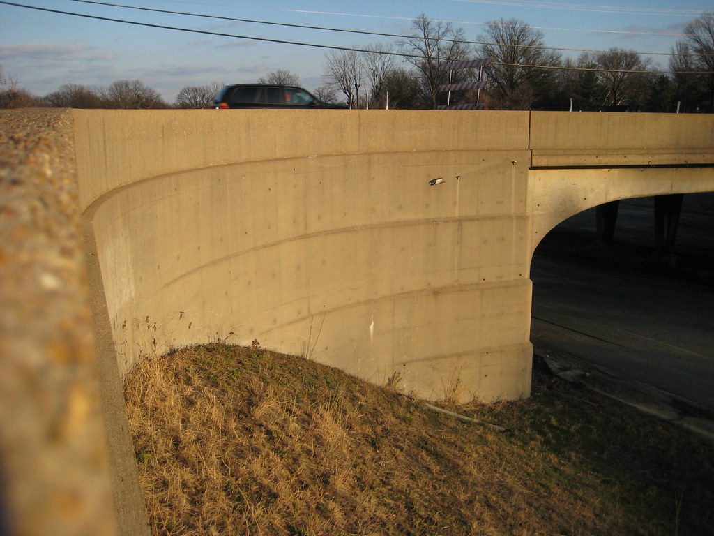
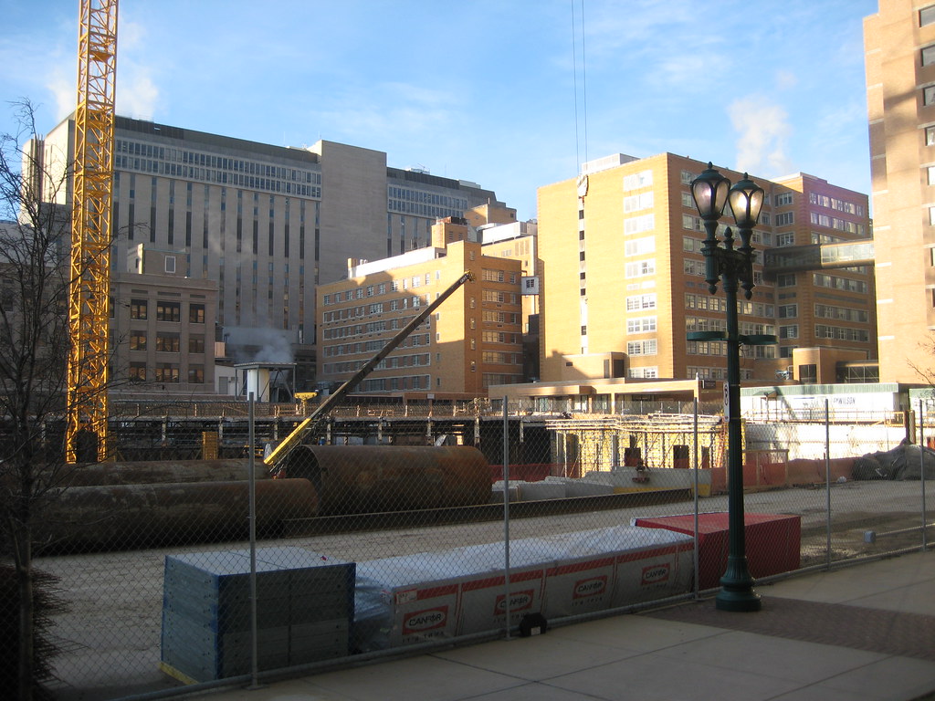
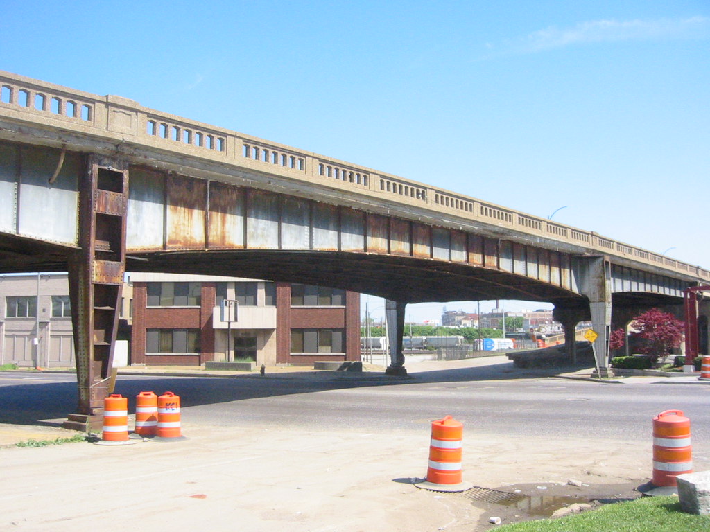
My post about the recent demolition of bridges along the now closed section of Highway 40 reminded me that I had taken a few shots of the old Vandeventer Viaduct (not sure if this was it's official name) before it was demolished a few years ago. The viaduct was a relic from the early days of Highway 40, or what was then known as the Oakland Express Highway and later the Red Feather Expressway. The first sections in the City were completed in 1938 and were connected to Chouteau Avenue just east of Manchester via this viaduct (see the red shaded area in the aerial photo below). Later when sections of the highway were built east to Downtown, the viaduct became more of a glorified extended exit/entrance ramp. Due to deterioration and the fact that it carried little traffic, the viaduct was demolished as part of the City's project to replace the also deteriorating Chouteau viaduct over the railroad tracks.

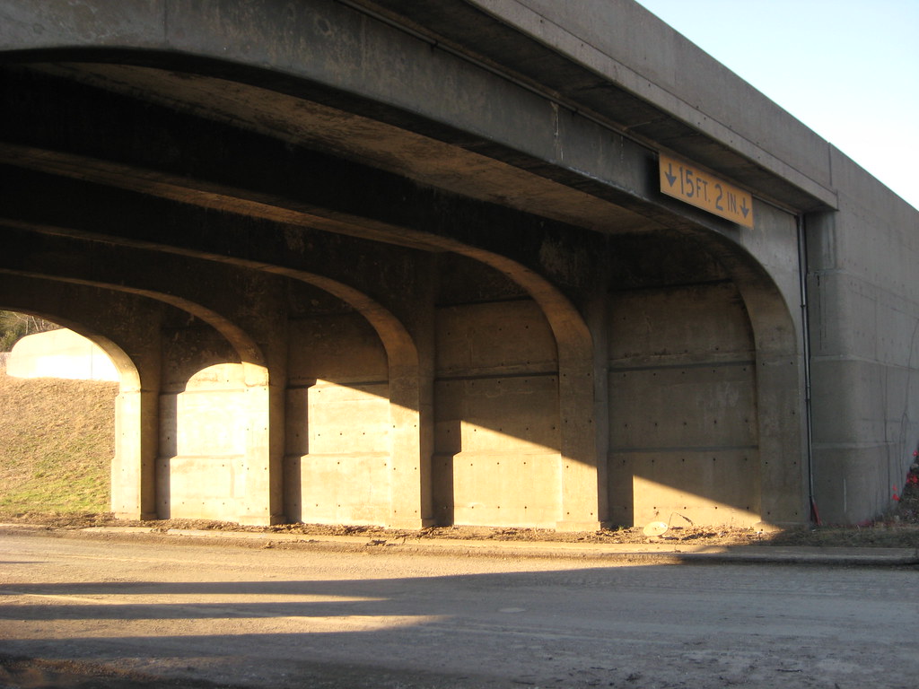
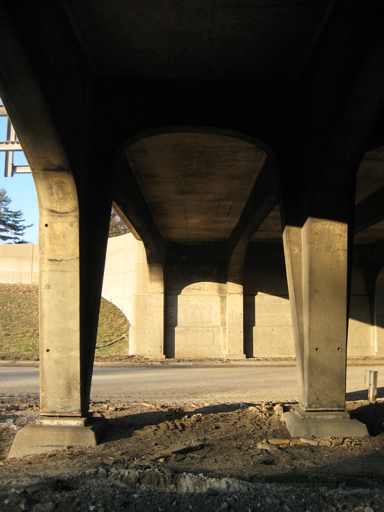
While the viaduct was neither an architectural nor engineering marvel, I was always fascinated by the detail in the photos below. The tapered riveted steel columns terminated at the bottom with roller bearings. The rounded bearings connected to the columns simply sat on the large base plate below and allowed the entire column to move back and forth as the long spans expanded and contracted due to hot and cold temperatures.
This is a detail that seems to never be used in new bridge construction. I suspect this is due to the fact that the unrestricted movement could prove disastrous during an earthquake.
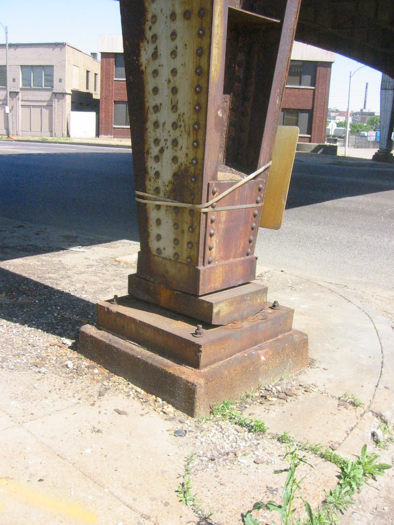
When I was a kid, we would often exit 40 and cross this viaduct to Chouteau so we could drive past what was possibly the best wall sign ever, "Brains 25 Cents", that was painted on the side of a 2 story building at Chouteau and Carr Lane, just east of Grand.

This photo and other interesting photos can be seen here on Tom Spine's site.

Like the viaduct, this building is now gone, and the BIG empty wasted space left where this and other buildings stood acts as a suburban style front lawn for SLU's new research building. I would like to think that eventually some of this blank lawn will be built upon with more research buildings, but I have a feeling I will be waiting for quite a while.

Tuesday, February 26, 2008

The Bridges of Highway 40


For this post we venture beyond the City limit to the nearby inner suburbs of Ladue and the western portion of Richmond Heights to view not the loss of a historic building in an urban context, but that of fragments of an aging transportation infrastructure undergoing total replacement. The portion of Highway 40 between Brentwood Boulevard and Spoede Road dates from 1936 to 1946. While it was no Merritt Parkway, many of the bridges constructed along this stretch of highway reflect the streamlined style that was applied to almost anything having to do with movement. The photo above is from a series of old photos available for view on thenewi64.org history page.
This section of roadway was a relic from another era, when cars traveled at a then considered speedy 45-50 mph. It was built with an almost parkway like feel, with two lanes each direction separated by a grassy median. This parkway like feel was, and still is to this day augmented by the fact that it bisects a community that by choice has preserved an almost rural feel by shunning office parks, mega-strip malls, and cookie cutter subdivisions that fill much of the modern suburban landscape.

Without a doubt the most interesting surviving structures were the overpasses at McKnight and McCutcheon. The McKnight bridge was a wonderful expression of streamlined modern with its curving stepped embankments.
The bridge at McCutcheon was a bit more fanciful with the lines of its embankments fanning out from the earth. There are more art deco influences in this bridge with its decorative pilasters flanking the span and a medallion at the graceful center columns.
Photographing the bridges was an almost surreal experience. For the first time in my life, I was walking down the middle of the highway! The bridges that I had known and appreciated since I was a child growing up nearby could now be fully enjoyed at a pace a bit slower than 70 mph. Details that I had never been able to see but for a nano second such as the gracefulness of the arches running perpendicular between the center columns or the way the lines of the embankments at McKnight continued through under the spans could now be captured.
I was not alone in my fascination. On a sunny but very chilly Sunday in mid-January there were several people out. Some like me were taking photographs, while others were simply out running or walking the dog. It was as if people had taken over the former highway as a a new recreation area or a linear park.
Location marker cast into each end of the overpass span at the median

A concrete sculpture commemorating the trans-Atlantic flight of Charles Lindbergh once graced the bridge over Lindbergh Boulevard. It was destroyed many years ago when the median in this section was filled with pavement. (photo from thenewi64.org)

The temporary loss of a highway
that played a major role in the decentralization of the City of St. Louis is certainly nothing to mourn, in fact my prediction that the ridiculously over hyped closure would be a non-event instead of the predicted doomsday have come to fruition. The fact that people have easily adjusted, and a large percentage have switched to nearby surface roads as opposed to heading to 70 or 44 leads me to believe that Steve Patterson's concept of replacing 40 with a boulevard including mass transit instead of an over-engineered high speed freeway might have actually been feasible. What is worth mourning is the loss of structures designed with a human hand from an era when good design was a standard feature of public infrastructure. The replacement bridges will be basic utilitarian structures. Today MoDot's idea of "good design" is some black iron fencing and some cutsie neo-historic lamp posts (click here to see a really lame rendering from their web site). More photos can be seen here on Flickr.

Friday, February 22, 2008

The Virtual White City and visualizing absence in the built environment

Today I stumbled upon this article in the Chicago Tribune about a new virtual reality exhibit at the Museum of Science & Industry featuring the World's Columbian Exposition of 1893 which has come to commonly be known as the "White City" due to its massive classically styled buildings executed in white plaster (that ultimately led to the style of the 1904 Worlds Fair that we here in the Lou so love to worship).

The virtual reality presentation was created by Lisa Snyder of UCLA's urban simulation team using photographs, plans and maps of the exposition. One sentence in the article jumped out at me, and that is: "the technology normally is used to record buildings, streets and infrastructure as they exist now, giving planners a way to visualize tearing down or restructuring the areas".

I thought to myself - wow wouldn't it be nice next time someone proposes to demolish the next landmark building to have this technology at arms reach to present to the powers that be what an awful idea it is to allow this to occur? I would think that in many cases this could be a very powerful tool.

You can check out some of the virtual reality of the Chicago exhibit here.


Monday, February 11, 2008

More Wash U Med/BJC demolitions


As I mentioned in the last post, the Washington University Medical Center has introduced an master plan for the next ten years that calls for over a dozen demolitions. Below are some photos of some of the buildings marked for removal as well as explanations given in Board Bill 443.

Just north of the Barnes south tower is a cluster of fairly benign buildings that will be removed for "replacement bed spaces", diagnostic, and support areas. Replacement beds?... Hmmm, what are they replacing? According to the plan, the Jewish Hospital Building at Kingshighway & Forest Park will be demolished near the end of the 10 year period.


Nothing is listed in the plan to replace this building. So are we to expect an empty green space at this prime corner? Such a solution is viewed by SLU as an excellent use of a corner in several locations. Maybe BJC is taking some pointers from father Biondi?


South of the Jewish Hospital Building, across Parkview Place, the Shoenberg School of Nursing Building is shown to be demolished on the attachment map, but is not specifically mentioned in the text. I would guess that this could be to make way for future expansion of Children's Hospital, which surrounds the building to the east and south.


On Forest Park, just east of St. Nicholas Greek Orthodox Church, what is now called the Shoenberg Research Building is shown to be demolished for an expansion of the large North Garage just to the east. The buildings original use is inscribed in stone "Shoenberg Nurses Residence" over the entrance.


At the corner of Forest Park and Euclid the Ettrick Building is also shown to be demolished. Besides the CID and Shriners Buildings listed as possible demolitions, this building is probably the most archticturally significant building scheduled for removal in the plan.
The plan states that the Ettrick is to be replaced with a new building to house expanded resident clinic facilities, of approximately 200,000 square feet and structured for vertical expansion.


I will admit that I have mixed opinions about this one. On one side, there is the the fact that the Ettrick is a very attractive building and reflects the scale and feel of the Central West End. On the flip side, there is the awkwardness of its floor levels. Built as an apartment building with its basement raised halfway out of the ground, retail spaces we later added at this lower level and creating an awkward moat to access the spaces. The low headroom in these basement spaces and the moat and stairs taking the majority of the sidewalk space is a bit of a clusterf***. The urbanist in me really likes the idea of a new larger building with attractive functional retail spaces and a real streetscape along Euclid.

East of Taylor, the plan shows that the various institutions of the Med Center have been on a buying binge over the last decade, purchasing of over a dozen properties. Each property is listed with an address, building name, and acreage. The fact that acreage is specified show that they consider the purchases mainly for the potential of new development on vacant land, even if there is a building present.


This unadorned building at 4500 Parkview Place is listed as potentially being re-skinned and expanded... or demolished.


Further east at 4340 Duncan Avenue, the former Crescent Electric Building is planned to be demolished to create a development pad for the Cortex area. The idea this large flexible industrial building could be adapted for re-use (as it has been before) seems to be beyond the cognitive mentality of planners for the area. For more information about this building, see this post from Ecology of Absence.


In 2006, Magee's bar at Taylor and Clayton Avenues was purchased and demolished (Google caught the scene in mid-demolition) with seemingly no plan for re-use of the property. Apparently bars are not seen as conducive neighbors by the WUMC. You can see a few shots of Magee's that I found by fellow Flickrites here, and a nice detail shot showing the cast iron and a classic striped awning here.


One block east, another great corner building, the last gasp of urbanism at the intersection of Newstead and Clayton was purchased in 2004 and demolished. Anyone out there have a photo of this one?

One positive item gleaned from the plan is a statement in the last paragraph of text describing the plan: "The Washington University Medical Center anticipates future development of properties fronting Forest Park Parkway and/or located north of Forest Park Parkway to incorporate retail and mixed uses, so as to further integrate these properties into the urban environment of the Central West End."

Wednesday, January 30, 2008

Wash U Med Contemplates Demolition of Shriners Hospital and Central Institute Buildings

1929 Photo of CID from the Bernard Becker Medical Library site

Shriners Hospital Building

Alderman Joe Roddy has introduced Board Bill #443 which if approved would adopt a new "Community Unit Plan" for the Washington University Medical Center. A Community Unit Plan is a zoning overlay plan that allows development flexibility that otherwise would not be possible under the current single use zoning districts. The bill was first read on January 11th, and will be heard at a meeting of the Housing, Urban Development and Zoning Committee on Wednesday January 30th at 10:00 am. The agenda has nine board bills to be heard in the one hour meeting.

The new plan outlines development of the medical center over the next 10 year from new construction, demolition, to an overall parking plan. Among a long list of items is the proposed possible demolition of both the Central Institute for the Deaf building at the southeast corner of Euclid and Clayton Avenues, and the Shriners Hospital building at the northeast corner of the same intersection.
screen shot of the bill's attachment map
buildings marked for demolition are shown on in red

The plan shows demolition of over a dozen buildings. Arguably the most architecturally significant of these are the Shriners and CID buildings. The Shriner's Hospital for Crippled Children was built in 1922, and the Central Institute for the Deaf in 1929. Both were designed by architect William B. Ittner and executed in variations of the Mediterranean revival style that was popular at that time for institutional buildings. While both buildings may be in need of some renovation, both are clearly in great condition and have been well maintained over the years. Demolition of such buildings of this merit would be inexcusable.

The plan describes dozens of changes contemplated across the medical campus. For Shriners it states "Planning is under way to either demolish or renovate the old Shriner's Hospital at the corner of Euclid and Clayton Avenues" and for CID "Plans to renovate the 818 S. Euclid building are being reviewed at this time to determine the most efficient use for the building, or its demolition".

More photos of the Shriners building can be seen here on my Flickr page, and Doug Duckworth also has photos of both buildings here. I will do a another post in the future covering some of the other buildings included in the plan for demolition.

Friday, January 18, 2008

Being a Slumlord is Hard Work

It's hard work to be a slumlord, so why bother. Tenants are messy and often want you to keep the buildings they live in from falling apart. Most tenants would complain if you bought the building they lived in and the windows and doors mysteriously disappeared. They would also probably get a little aggravated if they came home from work one day to find that the back of the building where they live was gone!
When you buy a building it's much easier to just evict everyone... but then what? It costs a lot of money to have the building demolished yourself. It would be much easier to get the City to condemn your building and order up an "emergency" demolition. For this to happen your building has to be in fairly bad shape, so you may want to enlist some "help" to get the building in the right condition to have the City step in and "take care of it" for you... such as having someone strip off the rear of the building brick by brick!
While its difficult to prove he connection here, the fact stands that there have been many buildings in certain north St. Louis neighborhoods that have fallen victim to what is known as brick rustling, in other words stealing brick, entire walls of brick (or in some cases the entire exterior) from standing buildings. For an alarming look at brick rustling take a look at this entry from Built St. Louis. Like a high percentage of buildings that are being ravaged by brick rustling, these buildings at St. Louis and Glasgow Avenues are owned by a certain developer from St. Charles County, best known for the sprawling, want-to-be a place with an ounce of character, known as Hellhaven. The Serial Building Killer owns literally hundreds of buildings and vacant lots in North St. Louis that he is compiling for some kind of massive new development... maybe "North Hellhaven"?... or maybe a giant industrial park like the one that his company is building east of Lambert Field? For the whole story about this one-man systematic quest to destroy North St. Louis, check out the The World of Blairmont section at Ecology of Absence.
This grouping of buildings, all of which have been ordered demolished by the City, lies at the southeast corner of the intersection. The ensemble consists of a three story multi-unit rowhouse building, a corner store with two stories of apartments above, and an alley house along Glasgow that gives urban form to what would ordinarily have been the side view of a back yard. It is a text-book example of the ubiquitous urbanism that St. Louis is losing at an alarming rate.


The sad irony in the loss of this group of buildings is that this very urban typology we are losing is now being emulated in some new outlying developments. Despite its marketing which might lead you otherwise, Hellhaven is a wormy mess of cul-de-sacs with many instances of homes backing, yes backing to the main roads of the development. However not far from Hellhaven a development called New Town at St. Charles is doing things a bit differently. Its planning and building forms emulate the way communities were built prior a century ago, before the automobile was made the sole center of the universe around which all planning rotates. The Aerial photo below is of Glasgow and St. Louis Avenues. Below is photo of a corner at New Town showing almost the same building arrangement with a pair of townhomes facing the main street and an alley house that is a separate residential unit fronting the side street. Parking access for all units is off the alley.


As for the current condition of the buildings, one could say that they are too badly damaged to save, right? I would say however that they are still able to be rehabilitated, based on examples of buildings in similar or worse condition. The corner building has sustained almost no damage, although the alley house admittedly is pretty bad. The photo below is of the rear of a pair of townhomes on Chouteau near Mississippi taken several years ago. The pair has since been fully re-built and restored.

The beautiful turreted corner building below is at the northeast corner of the intersection is known by some area residents as the "flatiron". It's more like a Flatiron in reverse, since it is wide at the front facing St. Louis Avenue, and tapers to almost nothing at the rear. Unlike the buildings to the south, this one has so far not been a victim of brick rustling. While there are signs of neglect, the only major damage to this building seems to be a small portion of the west wall around a window that is falling apart. This would only require some minor masonry re-building, yet the building and the group accross the street are being demolished this week!


Monday, December 24, 2007

A little good news for the holiday

Recently one of my readers commented about how negative most blog posts regarding the built environment are here in the Lou, and that sometimes its nice to see something positive. I have been told by more than one reader that Vanishing STL is the most depressing blog. I actually take that as a compliment, because seeing St. Louis' architectural heritage squandered and destroyed as often as it occurs around here angers me and sometimes depresses the hell out of me... so I make it a point to post about these acts of insanity to inform others of what is occurring, or as is the case with some posts, what occurred many years ago.

I agree though that sometimes its good to point out the positive things that are occurring in St. Louis even if they are small things, so I have decided that I will occasionally try to do so. So here goes...


This beautiful bridal dress shop opened just last week in the former Ludwig Aeolian Building at 1004 Olive. One of the buildings that been lingering for a while, the Ludwig Lofts has now almost been completed by LoftWorks. When I first entered the building about seven years ago, the roof was collapsing around one of the original skylights. To deal with the breach, the buildings former owner rigged up quite a contraption of a drainage system involving a blue tarp held up by some old desks and other odds and ends laying around and funneling into a piece of 4" PVC that was piped out a back window. This contraption actually did a pretty decent job of keeping the building dry.


This scene of several Christmas trees and lights in the windows of the Vangard Lofts caught my eye on the way back to the Globe Building garage a few days ago and made me think of how far we have come in the last several years. With that I leave you until next year... Happy Holidays!